Grading & stormwater
Every new detached home needs coordinated lot-grading review, elevations, drainage, and erosion controls.
Building in Virginia for 40+ years
A custom home designed around your Woodbridge property.
Understand zoning history, grading, drainage, utilities, and environmental conditions before finalizing the home.
Request a Lot Feasibility ReviewWhat Makes Woodbridge Different
Woodbridge includes older infill neighborhoods, Lake Ridge and Dale City planned communities, rural-edge parcels, stream corridors, and waterfront property. Two nearby lots can follow very different approval paths.
A house fitting inside basic zoning setbacks does not prove that the lot can support its grading, driveway, stormwater, utilities, and future improvements.
Every new detached home needs coordinated lot-grading review, elevations, drainage, and erosion controls.
Perennial streams, 100-foot buffers, flood hazard, and waterfront conditions can reduce the usable envelope.
Geotechnical work may identify marine clay, shrink-swell soil, groundwater, rock, asbestos, or undocumented fill.
RPC approvals, recorded building lines, utilities, drainage easements, trees, and HOA rules may control.
Zoning & Siting
Master plans, proffers, special-use conditions, subdivision plans, recorded building lines, lot coverage, easements, and HOA rules can be more important than the generic table.
RPC caution: Lake Ridge and Dale City lots require master-plan and recorded-file review before relying on a general setback.
Examples only—not a placement plan.
| District | Front | Side | Rear | Qualification |
|---|---|---|---|---|
| A-1 | 35 ft | 15 ft | 25 ft | Private access/ROW also matters |
| SR-1 | 35 ft | 10 ft | 25 ft | 20-ft side-street setback |
| R-2 | 35 ft | 10 ft | 25 ft | 20-ft side-street setback |
| R-4 | 30 ft | 10 ft | 25 ft | Generally 40% maximum coverage |
| R-6 | Property-specific | Property-specific | Property-specific | Housing type and approvals control |
| RPC | Plan-controlled | Plan-controlled | Plan-controlled | Review master plan and recorded files |
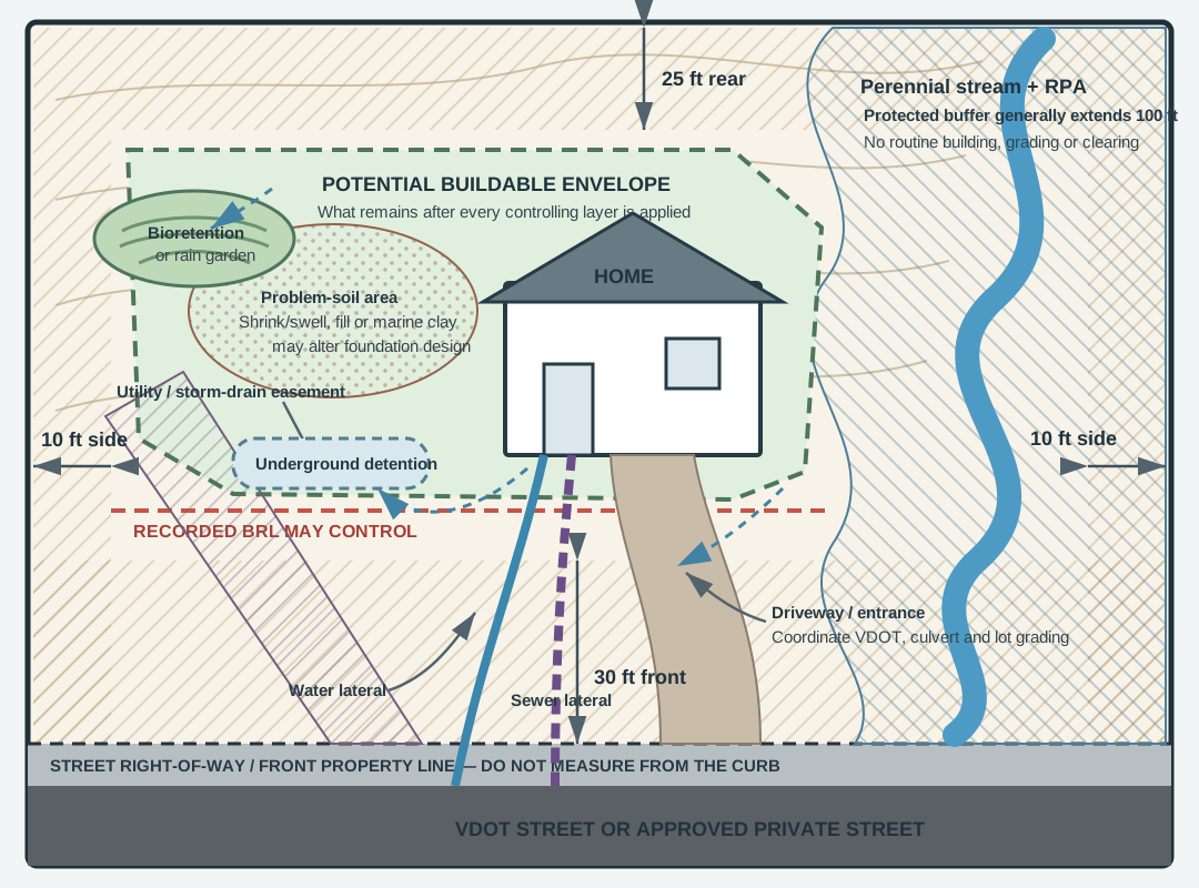
Lot Grading
The plan establishes how the home sits vertically and horizontally—not just whether its outline fits. Finished-floor, basement, garage, driveway, utilities, drainage, walls, and stormwater must coordinate.
Raising or lowering the house can create steep drives, drainage risk, walls, fill, excavation, or sewer conflicts.
Moving an entrance later is a major grading-plan revision. Evaluate garage orientation and access during concept design.
At 2,500 square feet, erosion and sediment-control requirements apply; demolition, access, utilities, and staging count.
Geotechnical recommendations may change footings, slabs, drainage, waterproofing, fill, walls, and schedule.
Beyond the Footprint
The home, infrastructure, environmental limits, and future improvements must be planned as one property.
A perennial stream can create a 100-foot protected buffer. Pools, garages, sheds, filling, grading, and clearing are generally prohibited within it.
Foundation, lowest floor, basement, equipment, driveway, utilities, docks, insurance, and outside-agency approvals may be affected.
High groundwater, rock, asbestos, shrink-swell, marine clay, fill, and floodplain soils may need specialized engineering.
A larger roof and driveway cannot redirect runoff toward neighbors; detention, bioretention, roof drains, and retaining walls must coordinate.
Confirm provider, main and lateral location, sewer depth, gravity service, easements, fees, and the Dale City wastewater arrangement.
Historical records are only a start. Bedroom capacity and protected system areas must support the replacement or enlarged home.
State-road connections may need VDOT permits; private streets require review of construction rights, ownership, restrictions, and truck access.
Easements can prohibit foundations, walls, pools, trees, grades, or crossings; retaining walls may require engineered permits.
Document lawful footprint, elevations, utilities, drainage, trees, and nonconforming conditions before demolition.
Reserve compliant space for pools, decks, garages, accessory space, stormwater, easements, lot coverage, and HOA approval.
A Coordinated Path
Confirm the GPIN, district, planned-community status, proffers, building lines, easements, HOA rules, and overlays.
Coordinate setbacks with grading, road access, utilities, stormwater, RPA, trees, and future improvements.
Complete the needed survey, civil, geotechnical, environmental, utility, onsite-system, or VDOT work.
Design around lot width, depth, topography, views, neighboring homes, solar exposure, and infrastructure.
Include demolition, soils, earthwork, walls, stormwater, access, utilities, erosion controls, and stabilization.
Coordinate county, utility, VDOT, Health District, environmental, and outside-agency approvals.
Before Final Design
Official Starting Points
Screen zoning and environmental layers before reviewing legal records.
Research plans, as-builts, rezonings, approvals, variances, and property files.
Submit and track plans, permits, payments, inspections, and public records.
Screen perennial streams, wetlands, buffers, and environmental-review needs.
Common Questions
There is no single Woodbridge standard. Conventional R-4 commonly uses 30/10/25; R-2 and SR-1 commonly use 35/10/25; A-1 commonly uses 35/15/25. RPC, R-6, PMR, and plan-controlled property require additional review.
Do not rely on that general ordinance number alone. Review the master RPC plan, subdivision approvals, proffers, housing type, and recorded building lines.
Yes. Prince William County requires a lot-grading plan for every new single-family home, prepared by a Virginia-certified civil engineer or land surveyor.
County guidance says a lot-grading plan will almost always include one. Recommendations can affect foundation type, soil mitigation, drainage, and construction.
A perennial stream can create a 100-foot RPA buffer where development, grading, and clearing are generally prohibited. Field verification should happen before design.
Dale City wastewater coordination is handled through Virginia American Water's Prince William District operation; many other public-utility projects coordinate with Prince William Water.
Do not assume so. Review the recorded language and holder requirements; written approval may be necessary.
Possibly, but reserve compliant space for lot coverage, setbacks, easements, RPA, stormwater, and permits during initial site design.
Send us the address or GPIN, survey or plat, utility or onsite-system records, desired home size and bedroom count, and future plans. We’ll identify the likely envelope, investigations, utility strategy, and approval path.
Request Your Woodbridge Lot ReviewBuild a custom home designed for your Woodbridge property.
This page provides general planning information, not a parcel-specific zoning, engineering, environmental, or legal determination. Confirm current requirements with agencies and licensed professionals.