Resource Protection Areas
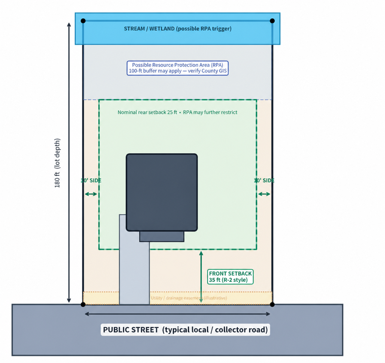
Perennial streams and certain wetlands can create 100-foot buffers that restrict disturbance, clearing, grading, and construction.
Building in Virginia for 40+ years
From compact suburban neighborhoods to semi-rural acreage, plan a home around the realities of your property.
Resolve zoning, Resource Protection Areas, utilities, soils, access, and site work before the architecture is finalized.
Request a Lot EvaluationA Diverse County
Prince William County contains planned communities, suburban infill, rural-edge properties, and agricultural land. The exact district, subdivision history, utility system, environmental mapping, and road access can substantially change what fits and how it is approved.
Illustrative Zoning Standards
Corner lots, planned districts, recorded plans, building lines, accessory uses, and current ordinance provisions can change these figures.
Critical rule: Never rely on a neighboring house or outdated survey. Confirm zoning and have the actual setbacks shown on a current survey.
| District | Front | Side | Rear | Typical context |
|---|---|---|---|---|
| A-1 Agricultural | 35 ft | 15 ft | 25 ft | Larger rural parcels |
| R-2 Suburban Residential | 35 ft | 10 ft | 25 ft | About 2 dwellings per acre |
| R-4 Suburban Residential | 30 ft | 10 ft | 25 ft | Higher-density single-family |
| SR, PMR & other districts | Varies | Varies | Varies | Confirm district-specific standards |
Example Plat
Local Peculiarities
Perennial streams and certain wetlands can create 100-foot buffers that restrict disturbance, clearing, grading, and construction.
Developed areas often use public service; rural properties may require a soil evaluation, approved septic design, and private well.
Residential permits, plan reviews, comment responses, inspection scheduling, and status tracking flow through the online system.
Clearing and land disturbance can trigger erosion-control, grading, and stormwater requirements that affect cost and schedule.
Airport safety, historic battlefield, environmental, and other planning areas may add design or review requirements.
New or modified entrances on state-maintained roads can require VDOT approval in addition to County permits.
Pre-Construction Roadmap
Complete zoning, survey, environmental, utility, access, and budget due diligence before final design.
Review the deed, title, easements, access rights, and private covenants.
Use County Mapper and Zoning Administration to confirm the parcel and district standards.
Map boundaries, topography, improvements, utilities, easements, streams, wetlands, and setbacks.
Review County GIS, flood zones, streams, wetlands, and any need for field delineation.
Confirm public connections and costs or coordinate septic evaluation, well permits, and other services.
Obtain preliminary geotechnical information and coordinate septic feasibility where applicable.
Determine whether County, VDOT, private-road, or maintenance requirements apply.
Place the home, drive, utilities, grading, stormwater, and outdoor areas inside the true envelope.
Include clearing, grading, erosion controls, utility laterals, driveways, and stormwater measures.
Coordinate typical ePortal review comments, RPA issues, and agency requirements early.
Include site work and meaningful contingency for unknown property conditions.
Coordinate zoning, land disturbance, septic or well, building, trade, and inspection requirements.
How the Process Flows
After feasibility, the team prepares architectural and site plans, submits through ePortal, responds to County review comments, obtains approvals, and coordinates construction inspections.
Zoning, survey, RPA, access, utilities, and soils
Architecture, site plan, engineering, and site budget
County ePortal, outside agencies, trades, and utilities
Approved work through inspections and occupancy
Official Starting Points
Research parcel, zoning, environmental, and other mapped layers.
Submit and track plans, permits, payments, comments, and inspections.
Confirm current zoning requirements and property-specific interpretations.
Understand mapped Resource Protection Areas and environmental review.
Share your address and survey. We’ll discuss the likely envelope, RPA and utility questions, site work, permitting path, and a realistic route to construction.
Request Your Lot ReviewThis page and example plat provide general educational information, not a survey, zoning determination, environmental delineation, permit approval, or legal opinion. Verify current parcel-specific requirements directly with Prince William County and licensed professionals.