RPAs & wetlands
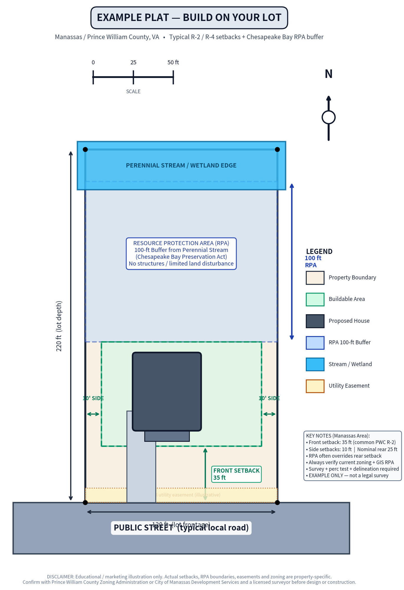
Perennial streams and certain wetlands can create a 100-foot buffer where disturbance is generally restricted.
Building in Virginia for 40+ years
A custom home designed for your land, lifestyle, and Northern Virginia surroundings.
Understand the correct jurisdiction, setbacks, environmental buffers, utilities, access, and site costs before finalizing the home.
Request a Lot EvaluationStart With the Parcel
The City of Manassas, Manassas Park, and surrounding Prince William County each administer their own zoning or development requirements. Confirm jurisdiction before applying any setback, utility, or permit assumption.
A current survey and early site review turn the property's setbacks, buffers, easements, utilities, and terrain into a practical design envelope.
Zoning & Typical Setbacks
These Prince William County figures are screening examples. City districts, corner lots, accessories, recorded plans, easements, and amendments can differ.
Critical rule: Never rely on a neighbor's house or an old survey. Obtain current zoning confirmation and have a surveyor show the actual setbacks.
| District | Front | Side | Rear | Typical lot |
|---|---|---|---|---|
| A-1 | 35 ft | 15 ft | 25 ft | Larger rural parcels |
| R-2 | 35 ft | 10 ft | 25 ft | About 20,000 sq ft |
| R-4 | 30 ft | 10 ft | 25 ft | About 10,000 sq ft |
What to Look Out For
Perennial streams and certain wetlands can create a 100-foot buffer where disturbance is generally restricted.
Confirm public water and sewer—or complete well, septic, bedroom-capacity, and soil feasibility work early.
Topography, FEMA flood zones, and geotechnical conditions influence foundations, access, drainage, and cost.
Utility and access rights, airport or historic areas, private covenants, and tree standards can shape the site plan.
Pre-Construction Roadmap
Early answers prevent redesign, permit delays, and under-budgeted site work.
Obtain the deed, title search, current plat, easements, and recorded restrictions.
Confirm whether the parcel is in the City of Manassas, Manassas Park, or Prince William County and obtain current district standards.
Map property lines, improvements, rights-of-way, utilities, easements, streams, wetlands, and terrain.
Review RPA, flood zones, wetlands, and any need for field delineation or consultant work.
Confirm water, sewer, electrical, gas, broadband, or the private-well and septic strategy.
Understand foundation soils, groundwater, rock, fill, and site-development risk.
Determine whether VDOT, city, private-road, or maintenance-agreement requirements apply.
Place the home, driveway, utilities, drainage, and outdoor areas inside the true envelope.
Allow for clearing, grading, erosion controls, drives, utility laterals, and stormwater.
Coordinate zoning, building, health, environmental, utility, and road approvals early.
Use a construction-loan structure that covers site work and unforeseen conditions.
Coordinate zoning, site approvals, well and septic if needed, building review, and trade permits.
How the Process Flows
After feasibility, the builder and design team prepare architectural and site plans, submit through the appropriate jurisdiction, respond to review comments, secure permits, and coordinate construction inspections.
Zoning, survey, RPA, access, utilities, and soils
Site plan, architecture, engineering, and budget
Zoning, site, health, building, road, and trades
Milestone inspections through final occupancy
Official Starting Points
Verify the mapped district and review current zoning requirements.
Submit and track Prince William County plans, permits, payments, and inspections.
Research city zoning, development, and building-permit requirements.
Screen perennial streams, wetlands, and Chesapeake Bay protected buffers.
Common Questions
The mailing address does not decide. A parcel may be in the City of Manassas, Manassas Park, or unincorporated Prince William County. Confirm the parcel and permitting jurisdiction before using any setback table.
A common screening example is 35 feet front, 10 feet side, and 25 feet rear. Corner lots, recorded plans, easements, and current amendments can change the usable envelope.
No. Use a current survey showing the property line, street right-of-way, access easements, and any recorded building line.
A Resource Protection Area can include a 100-foot buffer from a perennial stream or qualifying wetland. Construction, grading, and clearing are generally restricted within it.
They answer different questions. The survey establishes boundaries and terrain; geotechnical work evaluates soils and foundation conditions. Both are commonly important.
No. The neighboring home may have different zoning history, approvals, setbacks, easements, or environmental conditions.
Before final architecture. Early builder involvement helps align the home with site work, utilities, permit sequencing, schedule, and budget.
Send us the property address, survey or plat, desired home size, and any utility or onsite-system records. We’ll discuss setbacks, buildable area, site work, and a realistic path forward.
Request Your Manassas Lot ReviewThis page and example plat provide general educational information, not a survey, zoning determination, environmental delineation, permit approval, or legal opinion. Verify parcel-specific conditions with the appropriate jurisdiction and licensed professionals.