Grading & stormwater
The home, elevations, driveway, drainage, and detention strategy must work as one system.
Building in Virginia for 40+ years
Custom homes designed around Fairfax County’s zoning, drainage, and site conditions.
Understand the building envelope, grading strategy, utilities, and approval path before finalizing the architecture.
Request a Lot Feasibility ReviewWhat Makes Fairfax Different
Many new custom homes replace older houses in established neighborhoods, where mature trees, aging drainage systems, utility easements, and neighboring elevations already shape the property.
The real question is whether the home, driveway, grading, and stormwater system can fit without creating drainage, access, environmental, or construction problems. That makes early civil engineering especially important.
The home, elevations, driveway, drainage, and detention strategy must work as one system.
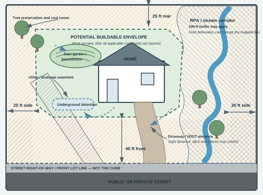
Streams, 100-foot buffers, floodplain, and field delineations can reshape the building envelope.
Marine clay, shrink-swell soil, fill, groundwater, and other conditions may change foundation design.
Root zones, utilities, drainage easements, and recorded building lines compete for limited infill space.
Zoning & Siting
The district table is only a screening tool. Cluster subdivisions, planned developments, proffers, recorded building lines, corner lots, through lots, pipestems, and height can all change the answer.
Confirm jurisdiction. The City of Fairfax is independent; Clifton and Vienna require separate town approvals.
Screening values only. Front, side, and rear setbacks shown in feet.
| District | Front | Side | Rear |
|---|---|---|---|
| RA | 60 ft | 50 ft | 50 ft |
| R-C | 40 ft | 20 ft | 25 ft |
| R-E | 50 ft | 20 ft | 25 ft |
| R-1 | 40 ft | 20 ft | 25 ft |
| R-2 | 35 ft | 15 ft | 25 ft |
| R-3 | 30 ft | 12 ft | 25 ft |
| R-4 | 30 ft | 10 ft | 25 ft |
Infill Grading & Stormwater
A new detached home generally needs a certified infill lot grading plan when more than 2,500 square feet is disturbed. Demolition, access, excavation, drives, utilities, walls, facilities, stockpiles, and stabilization can all count.
Finished-floor, basement, garage, driveway, and neighboring grades should be resolved together.
A rain garden or underground detention system needs the right elevation, drainage area, access, and outlet.
The plan must consider existing sheet flow, concentrated runoff, roof drains, driveway drainage, and outfall conditions.
Retaining walls, utility trenches, tree protection, and construction access can drive the actual disturbance area.
Parcel-Specific Review
A valid lot is not automatically a buildable lot. Layer every applicable condition before committing to the architecture.
A field delineation may move the mapped line, and work in the 100-foot buffer generally needs prior approval.
Review can affect floor elevation, basement feasibility, access, grading, fill, utilities, and insurance.
Tree preservation must account for excavation, compaction, utilities, grades, drainage, and neighboring trees.
Marine clay, shrink-swell soil, fill, groundwater, and asbestos areas can trigger testing or specialized construction.
Confirm sewer depth and gravity service, water extensions, or the full well-and-septic strategy early.
Legal access does not guarantee sight distance, acceptable grades, culverts, emergency access, or a permitted entrance.
Demolition needs separate approvals, utility disconnects, sewer cap-off or health coordination, and erosion controls.
Historic districts and Lower Occoquan protections can regulate siting, architecture, density, clearing, and review.
Deed-created or unusual parcels may need lot validation before substantial architectural investment.
Pools, garages, accessory units, generators, walls, and sheds have their own location and permit rules.
A Coordinated Path
Review zoning, development history, parcel validity, easements, utilities, environmental constraints, and likely site requirements.
Coordinate setbacks, driveway access, grading, stormwater, trees, utilities, and future improvements.
Complete the necessary survey, civil engineering, soils, septic, geotechnical, RPA, tree, utility, or entrance studies.
Design around the lot's dimensions, topography, views, access, neighboring properties, and infrastructure.
Account for demolition, clearing, earthwork, soil corrections, retaining, stormwater, utilities, and stabilization.
Coordinate building, grading, trade, VDOT, utility, health, and other approvals through final inspections.
Before Final Design
Existing records often reveal development conditions, prior engineering, utility assumptions, and constraints that are expensive to discover late.
Official Starting Points
County maps and neighboring records are screening tools—not replacements for property-specific engineering.
Identify the base district, then investigate the parcel's full zoning history.
Search approved infill plans, RPA studies, site plans, and development records.
Screen streams, buffers, and floodplain before obtaining field verification.
Screen marine clay, shrink-swell soils, asbestos areas, and other conditions.
Common Questions
It depends on the zoning district, whether the lot is conventional or cluster, planned-development approvals, proffers, recorded building lines, and special lot rules. Confirm the full zoning history with a current survey.
No. An R-1 lot may have been created through a cluster subdivision or may be governed by a rezoning, proffers, or an approved development plan with different requirements.
A new detached home generally requires an infill lot grading plan when more than 2,500 square feet will be disturbed. Most plans also require stormwater improvements.
Not every lot uses the same practice. A civil engineer calculates the requirement and evaluates the downstream outfall. Standardized options include planter boxes, rain gardens, and underground pipe detention.
Possibly, but relief is parcel- and history-specific and may require a Water Quality Impact Assessment, mitigation, or public hearing. Determine eligibility and the field-verified boundary before designing the home.
Not necessarily. The parcel must be in the approved service area and the connection must be technically feasible. Extensions, easements, permits, and applicant-funded costs may still apply.
Possibly, but it must work with the new grading plan and current right-of-way standards. Changes within a state right-of-way may require VDOT review and a permit.
Send us the property address or parcel number, survey or plat, intended home size and bedroom count, and plans for future improvements. We’ll help identify the buildable envelope, investigations, and likely approval path.
Request Your Fairfax County Lot ReviewBuild a home designed for your Fairfax County property.
This page provides general planning information, not a parcel-specific zoning, engineering, environmental, or legal determination. Confirm current requirements with the appropriate agencies and licensed professionals.